Wenglai Fm
Type Locality and Naming
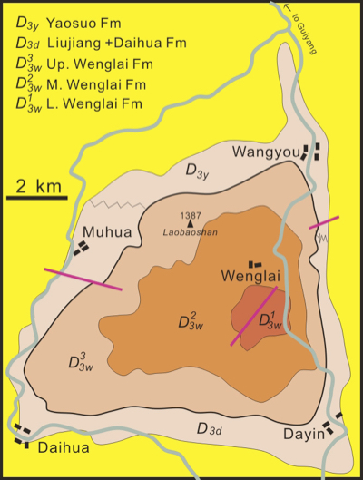
The stratotype section is located at the roadside between Wenglai Village and Wangyou Town, about 35 km south of Huishui county, Guizhou Province. There is a dome structure in the area between Wangyou, Dayin, Daihua and Muhua villages with the core consisting of Givetian Wenglai Fm, around which the upper Devonian to Carboniferous strata are developed forming flanks (Figure). It was named by Liao W.H. and Liang K. in 2019.
[Figure Simplified geological map showing the type locations of Daihua Fm and Wenglai Fm in Daihua and Muhua (D3d).]
Lithology and Thickness
Sandstone, limestone, siltstone. The Wenglai Formation is composed of quartz sandstone in the lower part, more than 250 m in thickness. Middle part is bioclastic limestone and clayey limestone with sandstone and mudstone interbeds, about 370 m thick. Upper part is siltstone and mudstone, 490 m thick.
Relationships and Distribution
Lower contact
The lower contact is unknown because of basal formation unexposed.
Upper contact
It is conformable contact with the overlying Liujiang Formation of Upper Devonian, being placed in the lithological change from sandstone to black shales and siliceous rocks.
Regional extent
It is restrictively distributed in Wangyou area.
GeoJSON
Fossils
It contains rugose corals Grypophyllum cf. primum,G. wangyouense, Cyathophyllumwenglaiense, Sinodisphyllum litvinovitshae, Temnophyllum majus, Argutastrea quadrigemina and Ceratophyllum simplex.brachiopods Stringocephalus burtini, S. obesus, Bornhardtina transversa, Acrothyris kwangsiensis, Indospirifer sp., Emanuella sp
Age
Depositional setting
It is interpreted as a nearshore shallow marine environment.
Additional Information
